
Why Planes Don't Fly Straight: The Great Circle
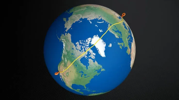
You’re watching a flight tracker. A plane leaves New York for Tokyo, and instead of heading west across the Pacific the way the map says it should, it climbs north. Up over Canada, past Alaska, brushing the edge of the Arctic before finally curving back down toward Japan. It looks like a detour. A big one. Like the pilot took a wrong turn somewhere over Greenland.
The plane is flying about as straight as it possibly can. The thing that’s lying to you is the map.
Why don’t planes fly straight?
They do. That’s the twist. The arc you’re looking at is the straight path. It only looks bent because you’re seeing it drawn on a flat rectangle, and the Earth is not a flat rectangle.
Here’s the trap. When you look at a world map and draw a line from New York straight across to Tokyo, your eye says “that’s the shortest way.” On the map, it is. But that map is a trick played on a globe, and the trick distorts distance the further you get from the equator. The line that looks shortest on paper is actually a longer way around the real planet.
To find the real shortest path, you have to stop trusting the map and start thinking about the sphere.
The map is the problem, not the route
Almost every world map you’ve ever seen is some version of the Mercator projection. It takes a round planet and peels it onto a rectangle, which is a useful thing to do. Straight lines of constant compass bearing stay straight, which is why sailors loved it for centuries.
But you can’t flatten a sphere without stretching something. Mercator’s cost is that it inflates everything near the poles. Greenland looks roughly the size of Africa. In reality Africa is about fourteen times larger. The map stretches the top and bottom of the world to fill the corners of the rectangle, and in doing so it quietly ruins your sense of distance up there.
So when a route runs through those stretched-out northern latitudes, the map makes it look like a long, looping arc. Undo the stretch, wrap the map back onto a globe, and the arc snaps into what it always was: a straight shot.
Why New York to Tokyo goes over the Arctic
Grab a globe if you have one. A real one, or the one on your phone that you can spin. Find New York, find Tokyo, and stretch a piece of string tight between them.
The string climbs north. Not because the North Pole is “on the way” in any signpost sense, but because on a sphere, for two cities up in the northern hemisphere, going up and over is genuinely shorter than going straight across. The high latitudes are closer together than the flat map suggests. Cutting through them saves real distance.
And the consequence is quietly huge. Most of the world’s big cities sit in the northern hemisphere. New York, London, Tokyo, Beijing, Los Angeles, Frankfurt. So the shortest paths between them nearly all bow toward the top of the world. That polar arc you keep noticing on the flight tracker isn’t a quirk of one route. It’s the default shape of long-haul flying between the places where most people actually live.
What a “great circle” actually means
The path that string traces has a name: a great circle.
Slice a sphere through its exact center and the edge of that cut is a great circle. The equator is one. Every line of longitude is one. There are infinitely many of them. The one that matters: between any two points on a globe, the shortest route always sits along the great circle that connects them.
That’s the whole idea. A great circle route is just the shortest path between two points on a sphere. It looks curved on a flat map for the same reason Greenland looks enormous: the map bent the truth to lie flat. The route was straight the entire time.
Want to see it for a specific pair of cities? Our flight time calculator works out the great-circle distance and estimated flight time between any two airports.
Where reality bends the geometry
Geometry draws the ideal line. Then the real world leans on it a little.
Wind. High up, around the altitudes jets cruise at, there are rivers of fast-moving air called jet streams that generally blow west to east. Flying east, a plane rides that push and arrives quicker. Flying west, it claws through the same wind and takes longer. A New York to London hop can come in meaningfully faster than the return, purely because one direction surfs the wind and the other fights it. On top of that, airlines will shift the route itself off the perfect great circle to chase the strongest tailwind or dodge the worst headwind.
Airspace and politics. Some countries don’t let certain airlines cross, or charge a fortune for the privilege, or sit in the middle of a conflict. The great circle doesn’t care about borders. Airlines have to.
Safety rules. A rule called ETOPS governs how far a twin-engine jet is allowed to stray from the nearest airport it could divert to in an emergency. Over big empty stretches of ocean or ice, that quietly tugs the route toward a path that always keeps a runway within reach.
None of this throws out the great circle. It’s still the skeleton. Winds, borders, and safety just add a few degrees of bend on top.
The bit nobody expects
Spread out a bunch of great circle routes between North America and Asia and you’ll notice something. They all funnel through roughly the same corner of the globe: Alaska. Specifically, they pass close to Anchorage.
Which is exactly why Anchorage became one of the busiest cargo airports on Earth. Back when planes couldn’t cross the Pacific in a single hop, nearly everything flying between the continents had to stop and refuel, and geometry decided that the natural place to stop sat right there in Alaska. That advantage never fully went away. Today FedEx and UPS still run enormous hubs there, planes touching down at the exact spot the shortest path always wanted to cross. A cold city in Alaska turned into a linchpin of global shipping because of the shape of the planet.
One more curiosity. Planes cross the Arctic constantly, but almost never Antarctica. Same geometry, opposite outcome. Northern cities cluster together, so their great circles pile up over the top of the world. Southern cities are scattered thinly across enormous oceans, so hardly any shortest path gains from cutting across the bottom. Add in the near-total lack of anywhere to divert down there, and the south stays empty while the north stays crowded.
Next time a plane on your screen swings north and looks lost, you’ll know it isn’t. It’s tracing the true shape of the shortest way home, drawn on a planet that no flat map has ever quite managed to tell the truth about.
Read next
How Old Is Too Old for a Plane?
Can a 30-year-old plane still be safe? Airliners age by pressurization cycles, one per flight, and the airframe gets watched down to the crack.
How Flying WorksWhere Does Dumped Jet Fuel Actually Go?
A jet spends hours dumping fuel over your city. Where does it all go? Released high up as a fine mist, most evaporates before it reaches the ground.
How Flying WorksWhy Your Window Seat Sometimes Has No Window
You paid for a window seat and got a blank wall. Windows are fixed to the fuselage, seats are not, so on jets like the E175 whole rows drift out of line.
Liked this?
Get the next one in your inbox. Aviation explained for the people who never lost the wonder. One email, no noise.